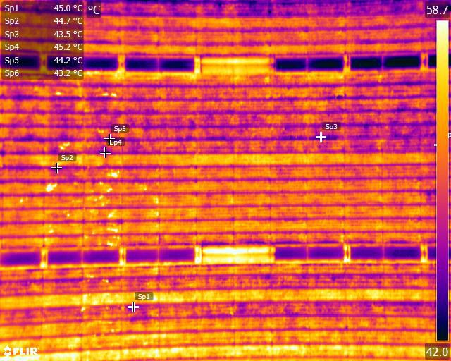
Solar PV Plant Survey using UAV

Odoo text and image block

Solar PV Plant Survey

Drones are nowadays evolving as the most accessible tool in the solar energy sector. Due to environmental conditions and logistical issues maintenance of solar power plants has always remained a challenge. Our Drone base technology can carry out quicker, safer, accurate and cost effective inspection of a plant effortlessly, that helps run the plants at its peak efficiency uninterruptedly. 

Brief 

Our aerial thermal imaging survey for solar farm can identify and precisely find flawed cells, natural garbage, string errors damaged diodes and PID faults on installation panels. Our built thermal imaging cameras are a perfect answer for distinguishing warm oddities and amplifying vitality creation. Flawed cells work at a temperature (hot or cold) unique to that of ordinary cells, which means we can without much of a stretch stick point the area of cell faults either by GPS referenced to a site delineate or by utilizing graphical overlays.

We Provide

We use Advanced Image Processing algorithms and Thermal Sensors on drones to detect abnormalities such as hot-spots, vegetation encroachment, dust covers etc. This technology provides information like exact module number, position and temperature details. 

We can Deliver a Range of Different types of Fault Detection Including:

Faulty Cells

Faulty cells operate at a temperature different to that of normal cells, making them easy to detect with infrared technologies.

String Errors

Accurately locate costly string errors – found on solar farms using string inverters  that could otherwise affect the performance of entire rows

Defective Diodes

Thermal imaging allows for the early detection of defective diodes, reducing potential voltage loss through photovoltaic modules.

Debris

Detect and locate debris that could otherwise cause risks to equipment and the environment.


We Support Solar Farm Engineering and Construction

Use drone surveying and mapping to plan and construct solar farm sites. Review 2D and 3D imaging to help accurately design string locations for maximum land use and solar charging.

Drive higher energy yields Perform thermal surveys of solar farms, leveraging solar string analysis to identify under performance issues. Inspect racking & mounting, inverters, panels, site vegetation or soiling issues quickly and inexpensively at utility-scale solar farms to maximize the site’s revenue.

Why We?

  • We work with temperature sensors, calibrated to meet industry standards 

  • We provide the best quality images at the great resolution 

  • Our service team can compute data much faster compared to manual methods 

  • We deliver results in very short time after data collection 

  • Our solution saves losses in power output that generally occur at Solar PV plants with defective panels 


Deliverables

  • Raw Thermal Images of the entire plant with Radiometric Data 

  • High-resolution orthomosaic image of the entire plant at the cm/ pixel,compatible with all GIS/CAD software  

  • KML or geographical data of hotspots 

  • Reports in the readable format with images indicating individual hotspots 

  • Actual and ambient temperature details of all hotspots